Alhambra

Route of the Caliphate, Spain

The Alhambra is an incredible blend of cultures resulting in one of the loveliest places I’ve ever seen.

Walking towards the Alhambra.

Main gate

Inside the Nasrid Palace; a marvel of Islamic artistry.

These carvings covered most surfaces.

Reflecting pool at the Nasrid Palace.

The Partal

Gardens

View from the Generalife.

Carving

Framed view I couldn’t resist.

Palace of Charles V

Patio gardens

Nasrid Palace

Ruta Day 10 – Granada!

Route of the Caliphate, Spain

Moclin to Granada – 15 miles plus a bus ride

Waking up at the church we breakfasted on bread and coffee then walked to a local walking path, Ruta del Golizino, and began a descent to the town of Olivares. 

On the the way we met a group of middle school students out for a walk on the path with their teachers. We enthusiastically exchanged Spanish and English phrases then went our separate ways.

Leaving the mountains we hit flat farmland surrounding Granada. Seeing this rich area helped us understand how the Granadian emirate remained independent for another 250 years after the fall of the Muslim capital of Córdoba.

Good morning Moclin.

View towards Olivares.

Alfred checking the route with the Moclin Castle in the background.

Down the trail!

On the way to Pinos Puente.

“Las flechas Amarillas” (yellow arrows), mark the Route of the Caliphate and were well placed to augment our maps.

Church in the hamlet of Bucor.

Horses on the outskirts of Pinos Puente. Arriving here things seemed grittier with more graffiti and abandoned factories.

One image said “this is the graffiti of unemployment”. We walked into town and took a bus to Granada.

Day Nine – Walking by Moonlight

Route of the Caliphate, Spain

Alcalá la Real to Moclin – 19 miles

Today we thought we’d do a quick visit to the Fortaleza then head on to Moclin. 

We started with the main museum in town and toured the rooms with artifacts from Neolithic to medieval times.

Some of the many interesting finds.


The Fortaleza and church are well worth a visit; blending original and reconstructed works with a wide array of presentation techniques to teach the visitor what life was like living in a town on the Christian – Muslim frontier.

Walking up the hill.

Through the first gate.

View from the tower.

A copy of a trebuchet used by Catholic attackers to defeat Muslim defenders after 9 months of siege in early 1300’s.

Inside of cathedral destroyed by Napoleon’s army during Peninsular War (per video shown in church).

We left Alcala at 3:30 and started the walk to Moclin through lowland farm country.

Asparagus fields

Climbing up towards Moclin.

Storm clouds gathered as the steep climb began. Dark settled in and we followed the white roads by the light of the moon.

A loop trail visiting caves and fountains just below Moclin.

Information on Moclin. As we entered the town fog settled in; restaurants were closed and we found no hotels.

We settled in for the night at the church; someone shined a light on Alfred but otherwise we slept through until morning.

Ruta Day Six – Across the Sierras Subetticas 

Route of the Caliphate, Spain

Across the Subbeticas 9 miles

Today we left the lovely town of Zuheros and spent the day hiking through the Subbeticas Nature Reserve. All day we heard the sounds of belled goats and smelled thyme and other herbs.

Adiós Zuheros!

Limestone caves were everywhere and one cave is enormous with prehistoric remains and cave art. (El Cueva de los Murciélagos)

Much of the land was covered with oak trees and flowers grew in the shady glens.

The amount of work to clear the land must have been incredible.

We saw bones of old houses and lots of animal bones.

Looking over the valley at the edge of the park.

At last we saw goats!

We laid out our bags at the base of a huge cliff filled with calling birds; as the sun set we heard an owl.

Sunset

Ruta Day Four and Five – Baena to Zuheros

Route of the Caliphate, Spain

Baena to Zuheros – 8 miles

Today’s walk was short with glorious scenery! Zuheros is in the Subbeticas Nature Preserve and it’s well worth the visit.

We stayed a second night in Zuheros and went to a bat cave. Photos forbidden so no record but a good hike and great guide.

Leaving Baena

Down into the valley from town.

Baena

This day we followed the Marbella River.

Olive groves

I was amazed to see trees in full bloom.

Almost to Zuheros.

Subbetica!

Castle at Zuheros.

We stayed an extra day in Zuheros and visited the bat caves. We just saw two bats but as our guide said “it’s not a zoo and the bats don’t have a schedule”.

Entrance to the cave.


Just inside, no photos allowed beyond this point. We went on to see cave paintings, burial sites and incredible cave formations.

Ruta Day Three – Castro Del Rio to Baena

Route of the Caliphate, Spain

Castro Del Rio to Baena – 14.3 miles

Prickly pear on the way to Baena.

For much of the day we followed the Guadajoz River.

An irresistible blank canvas for a sweetheart’s message.

It rained a bit then the sky was gorgeous with thick rolling clouds.

There are way stations for pilgrims along the route. To do this you need a pilgrim passport with stamps proving you are walking.

River bridge

Much of the day we walked by olive groves.

Olives have been grown in this area since Roman times and many of the trees are very old.

Baena!

There is a wonderful olive museum in Baena showing how olives are processed. This is a picture of many of the different types of oil produced. Olive oil is one of the main economic drivers.


Baena, like many of the towns we are passing through, has many layers of civilizations from Neolithic to Iberian to Roman to Visigoth to Moor to present day. There is a wonderful archeological museum showing finds from each era.

If you’d like to learn more about olive processing look here.

The head of Caesar found near Baena.

Ruta Day One – Cordoba to the Roman Ruins of Ategua 

Route of the Caliphate, Spain

Cordoba to Ategua – 16 miles

    Leaving Cordoba we crossed the Guadalquivir River by walking across the fortified Roman Bridge.

    Walking across the Roman bridge to start the day.

    Walking up into the hills from Cordoba.

    We soon left the paved road and walked along this gravel route. There were very few cars.

    The route is well marked.

    Iris bloomed at the top of the hills.

    The road narrowed and we passed fields of winter wheat.

    As the sun descended we passed gnarled olive trees covered with fruit ready for harvest.

    An interpretive sign showed we were nearly there.


    We arrived it just as the sun set.

    The site was closed unless you called ahead to make arrangements for a visit but we did see some of the remains from below.

    We camped nearby in an olive grove and watched stars the Romans saw. I dreamt of ring wraiths and history.

      Route of the Caliphate

      Spain

      Who can resist a route with a name like this? We’re landing in Madrid, spending a few days there, then taking a train to Toledo and Cordoba where the walking will start. (I am posting the outline of the trip then will fill in with more photos and details as we go.)

      La Ruta del Califato runs from Cordoba to Granada and is also known as the Camino Mozarabe de Santiago. It is a path that “en definitiva, que nos hará, sin duda, un poco más sabios” (a road that will make us without doubt, a little wiser).

      In January the average temperature is predicted to be around 60 during the day and 38 at night. We may do some camping but are aiming to stay in town most evenings.

      • Day one:  Cordoba to Castro del Rio – 39 km.

      Cordoba was founded in 152 BC by the Romans who made it the capitol of Hispania. The famous philosopher Seneca is from this city. Conquered by the Muslims in the 8th century they made it the capitol of their Islamic Emirate and it became a center for learning. The city was captured by King Ferdinand III in 1236 and has been under Spanish rule since.

      Castro del Rio is an ancient town on the banks of the Guadajoz river.

      • Day two:  Castro del Rio to Baena – 20 km.

      Baena is on the Marbella river and is renowned for olive oil and linens. It too was a Roman then Muslim city captured by King Ferdinand. It was on the historic border with the Muslim kingdom of Granada and is famous for its old town and castle.

      • Day three:  Baena to Alcaudete – 24.6 km.

      Alcaudete is famous for its 13th century Calatravo castle and the church of Santa Maria.

      • Day four:  Alcaudete to Alcala Real – 23.7 km.

      Alcala Real is thought to be one of the last places lived in by Neanderthal man. It was also a Roman city and ruled by Muslims. Watchtowers were built against Normans and Vikings. During the Napoleonic Peninsular War in the early 1800’s the upper city was burned. (Setting of part of the Netflix series Jonathan Strange and Mr. Norrell.)

      • Day five:  Alcala Real to Moclin – 21 km.

      Moclin was the site of a famous battle between Muslims and Christians in 1280.

      • Day six:  Moclin to Pinos Puenta – 16 km.

      Pinos Puenta is the home of the Spanish poet Federico Garcia Lorca: “Three hundred dark roses stain your white shirtfront”.
      The town is also well known for dishes such as migas, gazpacho, bean stews and noodle casseroles or fideos a la cazuela (even “noodle casserole” sounds more delicious in Spanish).

      • Day seven:  Pinos Puenta to Granada – 19 km.

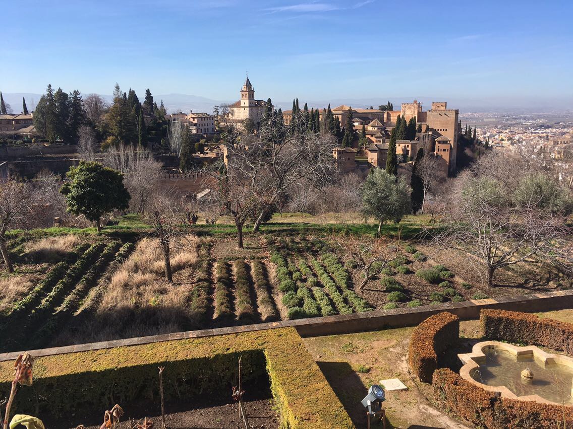
      Granada is home to the Alhambra and will get its very own post.


      Spain

      Spain

      Alfred and I are heading to Spain mid-January. Leo, our elderly dog, is holding down the fort and sleeping in front of the fire.

      Our plan is to fly into Madrid then take a train to Toledo then Cordoba. Once there we start walking along the Route of the Caliphate until we get to Granada. After Granada it’s a bus to Tarifa, the southernmost point of Spain, where we  pick up the E4 trail and the walk really starts.

      Route of the Caliphate

      The E4 is one of the longest walking paths in Europe and covers almost 10,000 km total. The portion in Spain is known as the Gran Recorrido 7 or GR7. This route is 1,900 km, (1,180 miles), long and runs from the southern tip of Spain, Tarifa, to the Pyrenees on the border with France. We are still debating whether to take the southern or northern portion; the southern portion is supposed to be more interesting but it’s also higher and we may run into snow.

      Alfred would like to summit Mulhacen, Spain’s highest peak; we’ll see if I go with him or not on that particular adventure!

      GR7 route in Spain

      Our plan is to do a combination of camping and staying in small hotels. We’re going to go as light as possible with gear; I’m just bringing my iPhone for photos and we’re downloading maps on our phones.

      More on this soon, in the meantime back to studying Spanish with Duolingo!